PVsell provides free access to ultra-high resolution imagery in urban areas, as we pay Google to give us the best imagery available.
We have integrated high resolution imagery providers functionality into our software, and now you can access the high resolution imagery from the top imagery providers directly from within PVsell. Add the imagery from the following high resolution imagery providers quickly and easily right from your project's 'Site' tab:
1. Nearmap
You can purchase Nearmap imagery directly from your Wallet in PVsell:
If you have a Nearmap account and would prefer to use your Nearmap data within PVsell, refer to this manual on how you can do that (note that if you have a Nearmap account that you've integrated into PVsell, then you won't be using your Wallet, you'll be using your Nearmap data):
2. MetroMaps
3. A few other options for uploading your own imagery
If the imagery that PVsell provides by default isn't high enough resolution for your needs, then you can upload your own imagery.
Here are some options for you to upload your own imagery:
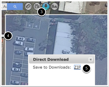
- Login to http://wms.metromap.com.au/metromap/
- Load up the address of interest
- Click the 'download icon'
- Select the area you wish to download by dragging a window over it
- Click 'Zip'
- Extract the file
- Find the file with the .jpg extension (the largest file) and upload it to PVsell and scale it.
You can also upload into PVsell your own images taken from a drone. While this won't avoid a site visit, it can still prevent you from having to climb on the roof.
There are plenty of drones out there. We've had the following recommended (in May 2017): DJI Mavic Pro. Apparently you can set it to fly a course that will capture the entire roof area using Drone Deploy software. Make sure you fly high enough to ensure the roof proportions are not bowed/fisheyed.
This is suitable for Metro and regional centres
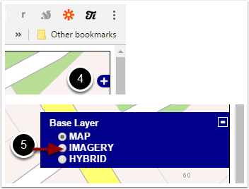
- Navigate to http://api.maps.vic.gov.au/fullscreen.php
- Manually locate the location of interest using the zoom and pan functionality on the roadmap
- Zoom as close as you can
- Click the '+' in the top right of screen
- Click 'IMAGERY'
- If you get a white screen, zoom out until you are served with the highest-possible resolution image
- Use a screen capture tool to save the image on screen to disk
- Upload the file to PVsell and scale it.
Six Maps offers outstanding resolution imagery for free across NSW
- Navigate to https://maps.six.nsw.gov.au/
- Use a screen capture tool to save the image on screen to disk
- Upload the file to PVsell and scale it.
The Queensland government provides an imagery layer that can be loaded into Google Earth Pro, and then a screenshot taken.
Great news! Now it's become much easier than downloading Google Earth – it's now online:
- Navigate to https://qldglobe.information.qld.gov.au/
- Locate your area
- Use a screen capture tool to save the imagery to your PC
- Upload the file to PVsell and scale it.
The WA government provides aerial imagery for purchase, but if you don't mind a watermark on your image then you can screenshot. Note that it is not ortho-rectified, meaning the images aren't directly from above and so dimensions won't appear accurately.
- In Internet Explorer or Firefox, navigate to https://www0.landgate.wa.gov.au/maps-and-imagery/imagery/aerial-photography/aerial
- Click 'Launch Map Viewer'
- When requested, run the Java application
- Enter the address of interest
- Select 'Aerial' to remove the lines and street names
- Either take a screenshot of the roof of interest, or
- Click "Buy Aerial Photo"
- Select from the list of Aerial Photos that are available - we recommend you find the one that is most 'from directly above'
- Select 'cut out the required area' and select the roof of interest
- Select the photo output properties, then click next
- Purchase the image, which will be emailed to you. The price should be about $24 for a JPEG (three times the price for other options).
- Save the file from your email/screenshot
- Upload your file into PVsell and scale it
Note that http://urbanmonitor-beta.landgate.wa.gov.au/ may have free imagery sometime soon

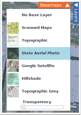
The Tasmanian government provides high resolution imagery, for free
- Navigate to http://maps.thelist.tas.gov.au/listmap/app/list/map
- Enter the address you want to find
- Click on 'Basemaps' in the top right
- Click 'State Aerial Photo'
- Use a screen capture tool to save the image on screen to disk
- Upload the file to PVsell and scale it.
0 Comments